Development and Assessment of Tools for Evaluating Stream Responses to Climate Change along Thermal Gradients
(Co-PI, US Forest Service and US Geological Survey, 2010-2014)
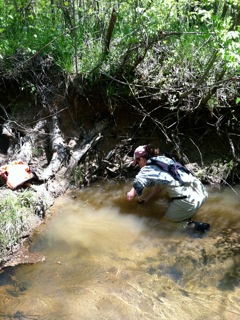
Climate change, particularly warming air temperatures, poses a threat to aquatic ecosystems and the biodiversity within. However, the extent of this threat is dependent on sensitivity of aquatic systems to changes in air temperature. To assess thermal sensitivity in local and regional watersheds, we have continuously sampled air and stream temperature on a total of 50 streams in the Roanoke River and Chattahoochee River Basins (n=28, n=22, respectively). During seasonal visits to sites, we have collected stream flow and water chemistry samples that will be used to estimate a snapshot of seasonal nitrogen loading. Stream temperature sensitivity to air temperature has been modeled statistically for 2011-2013 data and preliminary analyses have been conducted for other seasons. In addition, site-based watersheds have been delineated and a geodatabase of watershed and site characteristics have been developed. The geodatabase comprises a suite of potential explanatory factors that will be used in further statistical analysis of stream temperature regulation in the study basins. The objective is to identify watersheds that are sensitive to climate change and further, to identify vulnerable species (e.g. Brook trout). Click here to view presentation from 2014 Mid-Atlantic Ecological Society of America Meeting (College Park, MD).
(Co-PI, US Forest Service and US Geological Survey, 2010-2014)
Climate change, particularly warming air temperatures, poses a threat to aquatic ecosystems and the biodiversity within. However, the extent of this threat is dependent on sensitivity of aquatic systems to changes in air temperature. To assess thermal sensitivity in local and regional watersheds, we have continuously sampled air and stream temperature on a total of 50 streams in the Roanoke River and Chattahoochee River Basins (n=28, n=22, respectively). During seasonal visits to sites, we have collected stream flow and water chemistry samples that will be used to estimate a snapshot of seasonal nitrogen loading. Stream temperature sensitivity to air temperature has been modeled statistically for 2011-2013 data and preliminary analyses have been conducted for other seasons. In addition, site-based watersheds have been delineated and a geodatabase of watershed and site characteristics have been developed. The geodatabase comprises a suite of potential explanatory factors that will be used in further statistical analysis of stream temperature regulation in the study basins. The objective is to identify watersheds that are sensitive to climate change and further, to identify vulnerable species (e.g. Brook trout). Click here to view presentation from 2014 Mid-Atlantic Ecological Society of America Meeting (College Park, MD).
Regulating Services as Measures of Ecological Resilience on DoD Lands
(Co-PI, Department of Defense Environmental Security and Technology Program, 2010 -2014)
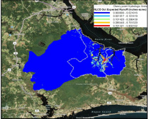
In its third year, this project has accomplished a suite of demonstration objectives regarding
the mapping and evaluation of regulating services on DoD lands, including ANG-MTC Fort Pickett (VA) and MCAS Cherry Point (NC). To date, we have developed and applied GIS-based models for quantifying regulating services (nitrogen regulation, surface water regulation, riparian filtration, and sediment retention) to both installations. We have prepared several static maps that can be used by installation personnel as well as ESTCP, the Army National Guard, and the Marine Corp. During 2012 and 2013, we interviewed key natural and cultural resource managers, military operation planners, and NEPA compliance officers at Fort Pickett and Cherry Point. From these interviews, we have developed 2 hypothetical scenarios that depict alternative futures regarding the management of these installations and compatible use buffer areas adjacent to the installation. This process requires the development and application of new GIS tools in conjunction with existing tools to map ecosystem service capacity. Conceptual underpinnings of our work on DoD lands is published in Ecological Complexity and was presented at the 2010 International Society for Landscape Ecology. Several manuscripts are inpreparation.
(Co-PI, Department of Defense Environmental Security and Technology Program, 2010 -2014)
In its third year, this project has accomplished a suite of demonstration objectives regarding
the mapping and evaluation of regulating services on DoD lands, including ANG-MTC Fort Pickett (VA) and MCAS Cherry Point (NC). To date, we have developed and applied GIS-based models for quantifying regulating services (nitrogen regulation, surface water regulation, riparian filtration, and sediment retention) to both installations. We have prepared several static maps that can be used by installation personnel as well as ESTCP, the Army National Guard, and the Marine Corp. During 2012 and 2013, we interviewed key natural and cultural resource managers, military operation planners, and NEPA compliance officers at Fort Pickett and Cherry Point. From these interviews, we have developed 2 hypothetical scenarios that depict alternative futures regarding the management of these installations and compatible use buffer areas adjacent to the installation. This process requires the development and application of new GIS tools in conjunction with existing tools to map ecosystem service capacity. Conceptual underpinnings of our work on DoD lands is published in Ecological Complexity and was presented at the 2010 International Society for Landscape Ecology. Several manuscripts are inpreparation.

Spatial Analysis of Relations among Conservation Practices, Aquatic Ecosystem Services, and Human Well-being in the Albemarle-Pamlico Basin
(Co-PI, US Geological Survey Aquatic Gap Program, 2010-2013)
Our overall goal was to conceptualize, quantify, and map key ecosystem services (ES) provided by conservation actions in the APB, then communicate findings to stakeholders for application and refinement. We aimed to highlight linkages among ES, HWB, and common management practices. The work comprised four sequential, but interactive objectives: 1) Develop tools and methods for analyzing spatial relations of conservation actions, selected ES, and HWB, 2) conduct analyses of spatial relations for and among selected ES, disservices, and HWB, 3) evaluate influences of conservation actions on ES capacity, ES flow, and HWB, and 4) produce maps, tools, and findings useful to stakeholders and managers in achieving conservation goals. Products from this project to-date include 5 published manuscripts, 2 in preparation, and 15 conference presentations.

Cost-effectiveness of riparian restoration as a recovery tactic for Roanoke logperch
(Co-PI, Virginia Dept. of Game and Inland Fisheries, 2013-2014)
Availability of unembedded stream substrate is widely believed to limit distribution, abundance, and recovery of Roanoke logperch. To be cost-effective, habitat management and restoration actions (eg, riparian re-forestation) need to be based on sound knowledge of fine-sediment sources and transport, as well as relations between watershed land cover and suitability of instream habitat for logperch. In particular, managers need to know where the greatest improvement in habitat conditions can be achieved with the least cost in resources (eg, money, time, political currency). However, relations between land cover and suitability of instream habitat for logperch have not been examined in ways that inform managers about where exactly to restore riparian vegetation or how likely such investments are to advance logperch recovery. We propose a spatially explicit analysis of a) watersheds and stream reaches that can be improved via reduced sediment loading by means of riparian restoration and b) how instream habitat suitability for logperch may be related to such improvements.

Collateral benefits of conservation areas in Virginia and North Carolina
Protected areas remain the most commonly used tool for in situ conservation; however growth in the USA’s system of public lands has stagnated while private land conservation continues to expand. Easements can provide a range of ecosystem services (ESs), but it is unknown whether conservation easements maintain ES capacities equivalent to public protected areas. Evaluation of the capacity of seven ESs on federal and state protected areas and conservation easements in the USA using spatially-explicit ES models and publicly available data indicated that ES capacities in easements were equal to or greater than capacities within state or federal protected areas for six of seven services and, when bundled together, conservation easements protected greater focal ES capacity than other conservation areas.
Environmental Conservation 2014 in press

Coming soon! Ecosystem
service equity: Who benefits from our conservation network?
Protected areas are critical tools to protecting the delivery of important ecosystem services (ES), but the presence of protected area does not necessarily ensure the flow of services to beneficiaries. The location of conservation areas in relation to people is a crucial component to quantifying the flow of ES. We suggest that delineating the geographic benefit zone, the area in which services could be conveyed to beneficiaries, is a helpful first step to quantifying ES flow. By mapping the flow of ES and analyzing the composition of beneficiaries, we were able to 1) identify gaps in the current conservation network, 2) determine whether benefit zones differed among conservation area types, and 3) evaluate the social equity of ES flow with selected demographic metrics of potential beneficiaries.
Protected areas are critical tools to protecting the delivery of important ecosystem services (ES), but the presence of protected area does not necessarily ensure the flow of services to beneficiaries. The location of conservation areas in relation to people is a crucial component to quantifying the flow of ES. We suggest that delineating the geographic benefit zone, the area in which services could be conveyed to beneficiaries, is a helpful first step to quantifying ES flow. By mapping the flow of ES and analyzing the composition of beneficiaries, we were able to 1) identify gaps in the current conservation network, 2) determine whether benefit zones differed among conservation area types, and 3) evaluate the social equity of ES flow with selected demographic metrics of potential beneficiaries.